
Focus on spectral sensing and optoelectronic application systems
Hyperspectral Imaging System
Time:2025-01-14
The Role of Remote Sensing Technology in Water Environment Monitoring
In recent years, the quality of water environments in China has continuously improved, imposing higher demands on water environment monitoring. Firstly, monitoring techniques need to be improved. Currently, China is still far behind other countries in terms of high-precision and high-sensitivity detection equipment and methods. Secondly, the monitoring system is not yet complete. China has not yet established a comprehensive water environment monitoring system, and the layout of monitoring points is not optimal, lacking effective integration and sharing of monitoring information. Additionally, the quality of monitoring data is not high. In some regions, water quality monitoring data are severely distorted, and there are instances of human interference.
01 Common Remote Sensing Data Used in Water Quality Monitoring
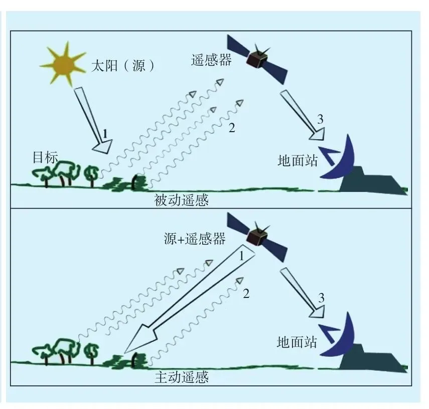
Satellite remote sensing is an advanced modern monitoring method that is easy to operate, covers large areas, and provides comprehensive data. Utilizing remote sensing techniques enables large-scale, three-dimensional, dynamic, and unrestricted data acquisition. Conducting extensive and three-dimensional regional ecological environment monitoring can provide strong technical support for ecological environment management and control within the region. In recent years, the use of remote sensing techniques for monitoring water bodies has generated a large amount of remote sensing data.
1.1 Hyperspectral Remote Sensing Data
Hyperspectral remote sensing holds significant importance in the field of water environment monitoring. It utilizes spectral information to monitor the water environment. By detecting the reflection and absorption characteristics of water bodies, data on nutrients such as suspended solids, organic matter, nitrogen, and phosphorus can be obtained. Hyperspectral remote sensing enables real-time monitoring of the dynamic evolution of water bodies and can achieve dynamic responses to water environment changes in a short time.
1.2 New Satellite Remote Sensing Data
The use of next-generation satellite remote sensing data has enabled in-depth analysis and research of water bodies. Firstly, high-precision satellite data can provide more detailed information about water conditions. Conventional remote sensing data can only capture basic features such as the type and area of water bodies, whereas the new generation of satellite remote sensing can capture detailed information on water body morphology, texture, and color, allowing for more comprehensive studies. Secondly, the new generation's high temporal and spatial resolution capabilities enable the rapid acquisition of large volumes of observational data, enhancing the effectiveness of water environment quality monitoring.
02 The Role and Advantages of Remote Sensing Technology in Water Environment Monitoring
2.1 Rapid, Large-Scale, and Three-Dimensional Ecological Environment Monitoring
Satellite remote sensing can significantly monitor the ecological environment of large areas while also focusing on key regions. Applying satellite remote sensing allows for quick and accurate monitoring of the ecological environment, providing a very flexible monitoring tool. On a large scale, it enables real-time dynamic monitoring of the regional ecological status, offering better insight into the area's ecological conditions and supporting the formulation of appropriate management measures. Remote sensing technology can monitor the ecological environment of large areas in real time, thus allowing for a comprehensive understanding of the regional ecological status.
2.2 Wide Range of Information Collection
Using satellite imagery for water environment monitoring can clearly display the status of water quality pollution, providing a theoretical basis for water pollution control. The information contained in remote sensing technology includes surface data and satellite data. Surface information encompasses surface spectral characteristics, surface cover types, and surface utilization types. Surface spectral characteristics include surface reflectance, the fluctuations in reflectance, and water surface reflectance. Remote sensing imagery provides information on the reflectance characteristics and spectral properties of surface features.
In the field of water environment quality monitoring, satellite remote sensing can be used to monitor the content of pollutants in water in real-time. By analyzing different types of water bodies, a remote sensing-based method for water quality assessment has been proposed.
2.3 Adaptability to Various Complex Water Environments
When monitoring the water environment, it has been found that water pollution levels are relatively high and pollution types are diverse. Therefore, various approaches must be used to monitor the water environment comprehensively. Using only one method has its limitations. Thus, when monitoring water quality, a combination of methods should be employed. For example, a comprehensive monitoring approach can be taken by using ground surveys and remote sensing.
When applying remote sensing methods for water environment quality monitoring, it is essential to detect and evaluate the composition of substances in the water environment. Additionally, remote sensing imagery can be used to monitor changes in water quality. Remote sensing has the advantage of adapting to various water environments. For instance, remote sensing imagery must be used to analyze hydrological characteristics when observing surface water bodies. In groundwater monitoring, remote sensing imagery is necessary to study certain characteristic parameters. For marine environment quality monitoring, remote sensing imagery is essential for monitoring water quality conditions. Furthermore, to better understand certain pollutants in urban wastewater, remote sensing technology is also required.
2.4 Three-Dimensional Dynamic Monitoring of Water Environment
Additionally, remote sensing technology can be used for three-dimensional, dynamic monitoring of water bodies. It allows for real-time monitoring of water pollution and its evolution, significantly enhancing the efficiency and accuracy of water quality monitoring. In practice, satellite imagery is used for three-dimensional dynamic observation of the water environment. The advantages include:
Real-Time Monitoring of Water Quality: Remote sensing enables real-time monitoring of water quality, facilitating timely prevention and control of pollution sources.
Real-Time Monitoring of Pollutant Content: Remote sensing can simultaneously acquire multiple parameters such as temperature, humidity, and light intensity, allowing for accurate estimation of pollutant content in the water environment. The research results can provide a basis for evaluating water pollution and formulating prevention and control strategies.
Real-Time Measurement of Temperature and Humidity: Studying the temperature and humidity conditions in the water environment is crucial for understanding the migration processes of pollutants. Understanding these changes helps in comprehending the spread of pollutants in the water environment, providing scientific evidence for developing appropriate remediation strategies.
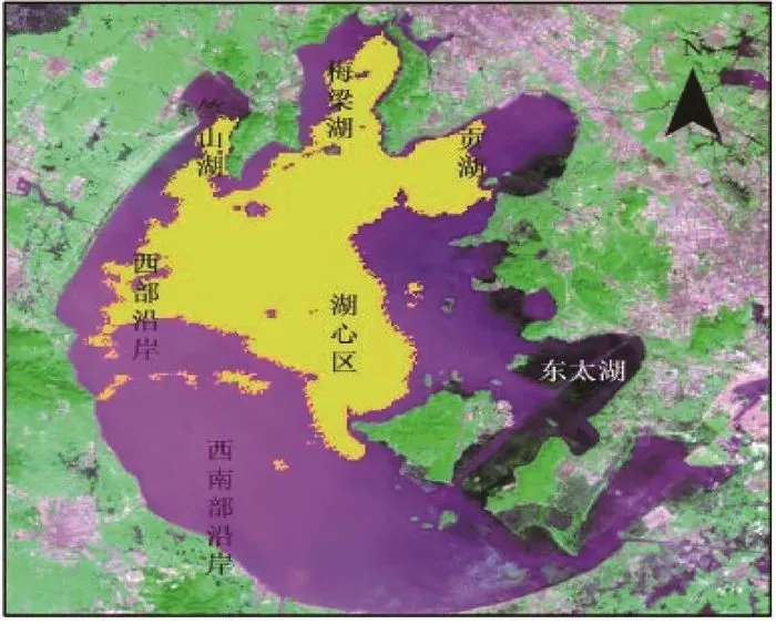
Figure 1: Application of Remote Sensing Technology in Water Ecological Environment Management (Algal Bloom Distribution Monitoring)
Recommendation:
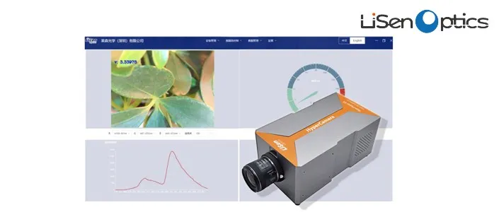
Hyperspectral Imaging System iSpecHyper-VS1000
The latest product specifically designed for fields such as police criminal investigation, forensic evidence identification, medical care, precision agriculture, and mineral geological exploration. It offers key advantages, including compact size, high frame rate, high spectral resolution, and high image quality, providing excellent cost performance. Utilizing a push-broom principle with transmission grating for hyperspectral imaging, the system integrates high-performance data acquisition and analysis processing. It features high-speed USB 3.0 interface transmission and a full-frame high imaging quality optical design. The objective lens interface is a standard C-Mount, allowing for the replacement of the objective lens based on user requirements.
The Role of Remote Sensing Technology in Water Environment Monitoring
In recent years, the quality of water environments in China has continuously improved, imposing higher demands on water environment monitoring. Firstly, monitoring techniques need to be improved. Currently, China is still far behind other countries in terms of high-precision and high-sensitivity detection equipment and methods. Secondly, the monitoring system is not yet complete. China has not yet established a comprehensive water environment monitoring system, and the layout of monitoring points is not optimal, lacking effective integration and sharing of monitoring information. Additionally, the quality of monitoring data is not high. In some regions, water quality monitoring data are severely distorted, and there are instances of human interference.
01 Common Remote Sensing Data Used in Water Quality Monitoring
Satellite remote sensing is an advanced modern monitoring method that is easy to operate, covers large areas, and provides comprehensive data. Utilizing remote sensing techniques enables large-scale, three-dimensional, dynamic, and unrestricted data acquisition. Conducting extensive and three-dimensional regional ecological environment monitoring can provide strong technical support for ecological environment management and control within the region. In recent years, the use of remote sensing techniques for monitoring water bodies has generated a large amount of remote sensing data.
1.1 Hyperspectral Remote Sensing Data
Hyperspectral remote sensing holds significant importance in the field of water environment monitoring. It utilizes spectral information to monitor the water environment. By detecting the reflection and absorption characteristics of water bodies, data on nutrients such as suspended solids, organic matter, nitrogen, and phosphorus can be obtained. Hyperspectral remote sensing enables real-time monitoring of the dynamic evolution of water bodies and can achieve dynamic responses to water environment changes in a short time.
1.2 New Satellite Remote Sensing Data
The use of next-generation satellite remote sensing data has enabled in-depth analysis and research of water bodies. Firstly, high-precision satellite data can provide more detailed information about water conditions. Conventional remote sensing data can only capture basic features such as the type and area of water bodies, whereas the new generation of satellite remote sensing can capture detailed information on water body morphology, texture, and color, allowing for more comprehensive studies. Secondly, the new generation's high temporal and spatial resolution capabilities enable the rapid acquisition of large volumes of observational data, enhancing the effectiveness of water environment quality monitoring.
02 The Role and Advantages of Remote Sensing Technology in Water Environment Monitoring
2.1 Rapid, Large-Scale, and Three-Dimensional Ecological Environment Monitoring
Satellite remote sensing can significantly monitor the ecological environment of large areas while also focusing on key regions. Applying satellite remote sensing allows for quick and accurate monitoring of the ecological environment, providing a very flexible monitoring tool. On a large scale, it enables real-time dynamic monitoring of the regional ecological status, offering better insight into the area's ecological conditions and supporting the formulation of appropriate management measures. Remote sensing technology can monitor the ecological environment of large areas in real time, thus allowing for a comprehensive understanding of the regional ecological status.
2.2 Wide Range of Information Collection
Using satellite imagery for water environment monitoring can clearly display the status of water quality pollution, providing a theoretical basis for water pollution control. The information contained in remote sensing technology includes surface data and satellite data. Surface information encompasses surface spectral characteristics, surface cover types, and surface utilization types. Surface spectral characteristics include surface reflectance, the fluctuations in reflectance, and water surface reflectance. Remote sensing imagery provides information on the reflectance characteristics and spectral properties of surface features.
In the field of water environment quality monitoring, satellite remote sensing can be used to monitor the content of pollutants in water in real-time. By analyzing different types of water bodies, a remote sensing-based method for water quality assessment has been proposed.
2.3 Adaptability to Various Complex Water Environments
When monitoring the water environment, it has been found that water pollution levels are relatively high and pollution types are diverse. Therefore, various approaches must be used to monitor the water environment comprehensively. Using only one method has its limitations. Thus, when monitoring water quality, a combination of methods should be employed. For example, a comprehensive monitoring approach can be taken by using ground surveys and remote sensing.
When applying remote sensing methods for water environment quality monitoring, it is essential to detect and evaluate the composition of substances in the water environment. Additionally, remote sensing imagery can be used to monitor changes in water quality. Remote sensing has the advantage of adapting to various water environments. For instance, remote sensing imagery must be used to analyze hydrological characteristics when observing surface water bodies. In groundwater monitoring, remote sensing imagery is necessary to study certain characteristic parameters. For marine environment quality monitoring, remote sensing imagery is essential for monitoring water quality conditions. Furthermore, to better understand certain pollutants in urban wastewater, remote sensing technology is also required.
2.4 Three-Dimensional Dynamic Monitoring of Water Environment
Additionally, remote sensing technology can be used for three-dimensional, dynamic monitoring of water bodies. It allows for real-time monitoring of water pollution and its evolution, significantly enhancing the efficiency and accuracy of water quality monitoring. In practice, satellite imagery is used for three-dimensional dynamic observation of the water environment. The advantages include:
Real-Time Monitoring of Water Quality: Remote sensing enables real-time monitoring of water quality, facilitating timely prevention and control of pollution sources.
Real-Time Monitoring of Pollutant Content: Remote sensing can simultaneously acquire multiple parameters such as temperature, humidity, and light intensity, allowing for accurate estimation of pollutant content in the water environment. The research results can provide a basis for evaluating water pollution and formulating prevention and control strategies.
Real-Time Measurement of Temperature and Humidity: Studying the temperature and humidity conditions in the water environment is crucial for understanding the migration processes of pollutants. Understanding these changes helps in comprehending the spread of pollutants in the water environment, providing scientific evidence for developing appropriate remediation strategies.
Figure 1: Application of Remote Sensing Technology in Water Ecological Environment Management (Algal Bloom Distribution Monitoring)
Recommendation:
Hyperspectral Imaging System iSpecHyper-VS1000
The latest product specifically designed for fields such as police criminal investigation, forensic evidence identification, medical care, precision agriculture, and mineral geological exploration. It offers key advantages, including compact size, high frame rate, high spectral resolution, and high image quality, providing excellent cost performance. Utilizing a push-broom principle with transmission grating for hyperspectral imaging, the system integrates high-performance data acquisition and analysis processing. It features high-speed USB 3.0 interface transmission and a full-frame high imaging quality optical design. The objective lens interface is a standard C-Mount, allowing for the replacement of the objective lens based on user requirements.
Previous: Hyperspectral Imaging System
Next: No data
PRODUCTS
Copyright © 2025 Lisen Optics (Shenzhen) Co., Ltd.