Get Your Free Spectral Analysis Solution.
Tell us about your requirements. Our experts will contact you within 24 hours.
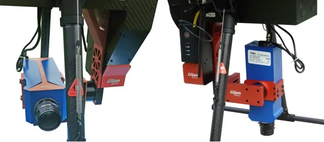
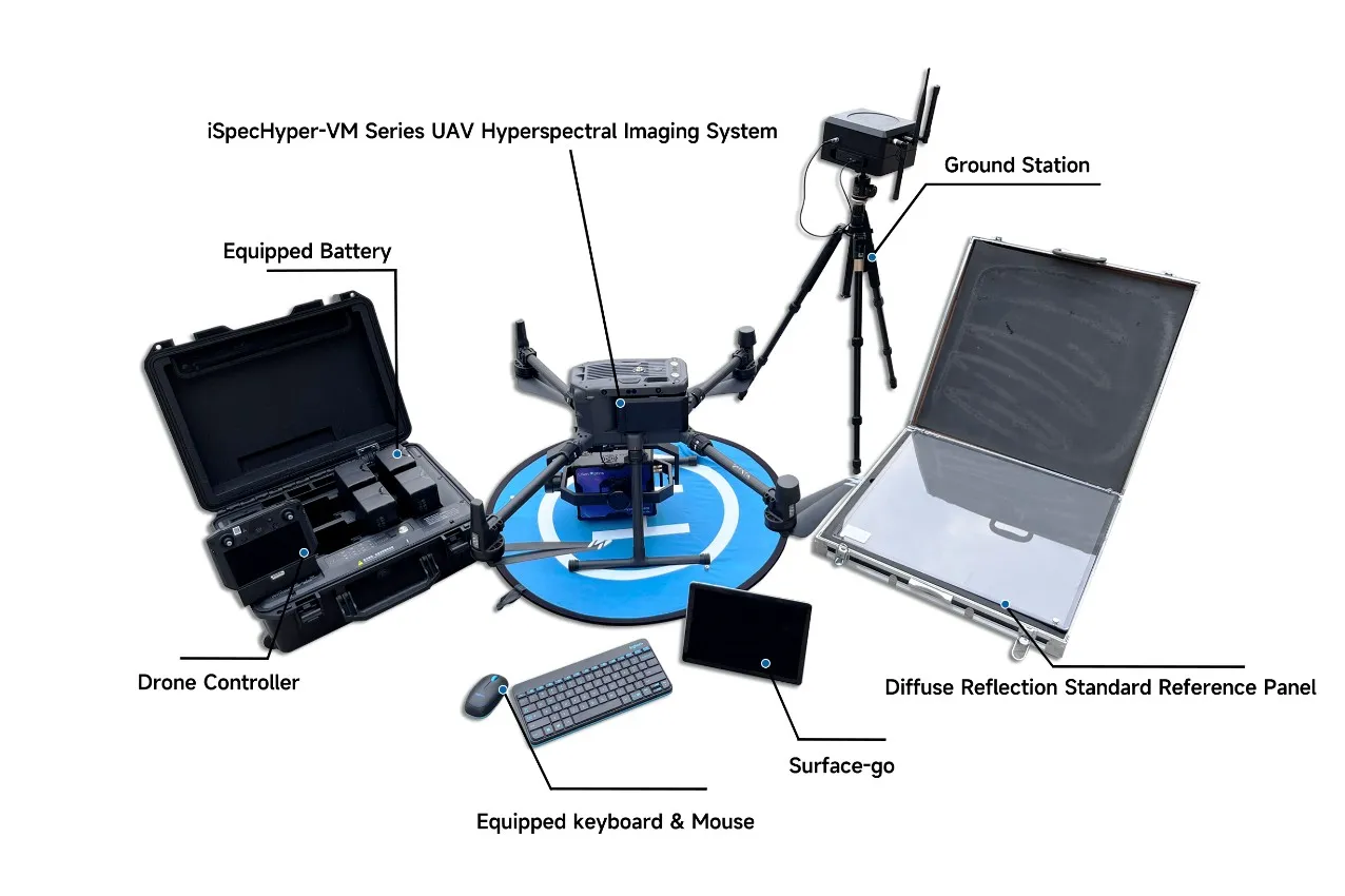
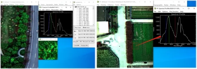
The iSpecHyper-VM series multi-rotor unmanned aerial vehicle (UAV) hyperspectral imaging system is a product launched by LiSen Optics, based on a small multi-rotor UAV-borne hyperspectral imaging system. The system consists of a hyperspectral imaging camera, stable gimbal, onboard control and data collection module, onboard power supply module, and other components. This series of UAV-borne hyperspectral imaging systems employs a unique internal or external scanning system and stabilization system, successfully overcoming the issue of poor imaging quality caused by vibrations in small UAV systems when carrying push-broom hyperspectral cameras. Additionally, the system features high spectral resolution and excellent imaging performance.
The iSpecHyper-VM series multi-rotor unmanned aerial vehicle (UAV) hyperspectral imaging system is a product launched by LiSen Optics, based on a small multi-rotor UAV-borne hyperspectral imaging system. The system consists of a hyperspectral imaging camera, stable gimbal, onboard control and data collection module, onboard power supply module, and other components. This series of UAV-borne hyperspectral imaging systems employs a unique internal or external scanning system and stabilization system, successfully overcoming the issue of poor imaging quality caused by vibrations in small UAV systems when carrying push-broom hyperspectral cameras. Additionally, the system features high spectral resolution and excellent imaging performance.
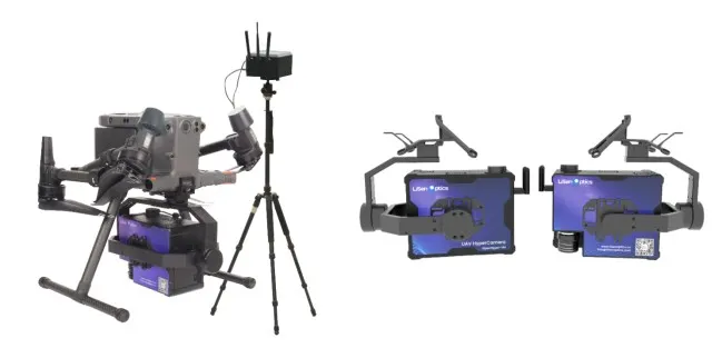
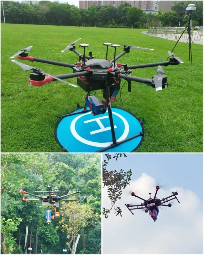
Equipped with a custom-developed high-performance stable gimbal, the iSpecHyper-VM series UAV-borne hyperspectral imaging system can effectively reduce image distortion and blurring caused by UAV shaking during flight. The system is perfectly compatible with DJI M300RTK/M600 pro drones and supports various types of similar drones. The iSpecHyper UAV-borne hyperspectral imaging system is widely used in industries such as agriculture, forestry, and aquatic environments. It supports accessory upgrades and customized development, providing cost-effective solutions for high-end application fields such as educational research, smart agriculture, target recognition, military anti-camouflage, and more.
|
Capable of being Mounted on the DJI M300 RTK UAV |
iSpecHyper-VM100 UAV Hyperspectral Camera |
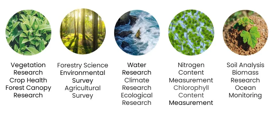
Typical Applications
Technical Advantages and Features
● Spectral range of 400-1000nm, with a resolution better than 3nm
● High-performance spectroscopic system, large target area CMOS/CCD/InGaAs (TE Cooled) image sensors, offering high sensitivity and high image quality
● Comprehensive target surface high imaging quality optical design, with high spectral resolution, wide field of view, and spot array diameter better than 0.5 pixels
● Implementation of automatic target identification and real-time display of automatic reflectance calculation, real-time display of target spectral dynamic recognition
● Real-time spectral reflectance classification of ground observation targets and real-time color classification distribution display, automatic identification of potential ground object classification
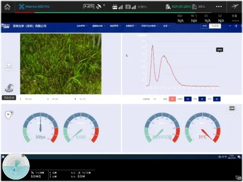
● Synchronized with GPS triggering, achieving visible light photo matching with synchronized GPS information; real-time observation of aircraft sampling points through the ground real-time data platform, with the ability to utilize ground-based setup for flight path preview, point-by-point sampling route setup, data preview, and correction functions
● 15-million-pixel HD camera for real-time visibility and monitoring of shooting effects, dynamic real-time display of hyperspectral images, and spectral curves; real-time synthesis of single-band, true and false color images
● Hyperspectral camera control supports data collection, automatic exposure, automatic scan speed matching, auxiliary camera functions, supports remote remote control, supports cruising, inertial collection mode
● Real-time common vegetation index calculation functions: Normalized Vegetation Index (NDVI), Ratio Vegetation Index (RV), Enhanced Vegetation Index (E/I), Atmospheric Resistance Vegetation Index (ARVI), Improved Red Edge Ratio Vegetation Index (mSR705), Vogelmann Red Edge Index (VOG), Photochemical Reflectance Index (PR), etc. These can be obtained without third-party software, providing broadband greenness, narrowband greenness, and over 20 other common vegetation indices, and supporting user-defined algorithms
● Data format perfectly compatible with Envi and other data analysis software
Technical Advantages
Hyperspectral Graph
Software’UI
|
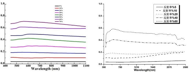
1.2m×1.2m UAV Target Spectral Reflectance |
1.2m×1.2m UAV Target Spectral Reflectance |
Equipped with a custom-developed high-performance stable gimbal, the iSpecHyper-VM series UAV-borne hyperspectral imaging system can effectively reduce image distortion and blurring caused by UAV shaking during flight. The system is perfectly compatible with DJI M300RTK/M600 pro drones and supports various types of similar drones. The iSpecHyper UAV-borne hyperspectral imaging system is widely used in industries such as agriculture, forestry, and aquatic environments. It supports accessory upgrades and customized development, providing cost-effective solutions for high-end application fields such as educational research, smart agriculture, target recognition, military anti-camouflage, and more.
|
Capable of being Mounted on the DJI M300 RTK UAV |
iSpecHyper-VM100 UAV Hyperspectral Camera |
Typical Applications
Technical Advantages and Features
● Spectral range of 400-1000nm, with a resolution better than 3nm
● High-performance spectroscopic system, large target area CMOS/CCD/InGaAs (TE Cooled) image sensors, offering high sensitivity and high image quality
● Comprehensive target surface high imaging quality optical design, with high spectral resolution, wide field of view, and spot array diameter better than 0.5 pixels
● Implementation of automatic target identification and real-time display of automatic reflectance calculation, real-time display of target spectral dynamic recognition
● Real-time spectral reflectance classification of ground observation targets and real-time color classification distribution display, automatic identification of potential ground object classification
● Synchronized with GPS triggering, achieving visible light photo matching with synchronized GPS information; real-time observation of aircraft sampling points through the ground real-time data platform, with the ability to utilize ground-based setup for flight path preview, point-by-point sampling route setup, data preview, and correction functions
● 15-million-pixel HD camera for real-time visibility and monitoring of shooting effects, dynamic real-time display of hyperspectral images, and spectral curves; real-time synthesis of single-band, true and false color images
● Hyperspectral camera control supports data collection, automatic exposure, automatic scan speed matching, auxiliary camera functions, supports remote remote control, supports cruising, inertial collection mode
● Real-time common vegetation index calculation functions: Normalized Vegetation Index (NDVI), Ratio Vegetation Index (RV), Enhanced Vegetation Index (E/I), Atmospheric Resistance Vegetation Index (ARVI), Improved Red Edge Ratio Vegetation Index (mSR705), Vogelmann Red Edge Index (VOG), Photochemical Reflectance Index (PR), etc. These can be obtained without third-party software, providing broadband greenness, narrowband greenness, and over 20 other common vegetation indices, and supporting user-defined algorithms
● Data format perfectly compatible with Envi and other data analysis software
Technical Advantages
Hyperspectral Graph
Software’UI
|
1.2m×1.2m UAV Target Spectral Reflectance |
1.2m×1.2m UAV Target Spectral Reflectance |
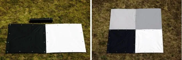
![]() Standard Panel
Standard Panel
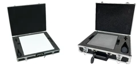
1. Spectral Range: 250-2500nm
2. Reflectance: 3%/5%/10%/20%/30%/40%/50%/60%/70%/80%/≥98% (with original factory traceable reflectance data testing report)
3. Size: 500×500mm
4. Professional portable carrying case, PET dust protection, with dust removal kit.
![]() Standard Panel
Standard Panel
1. Spectral Range: 250-2500nm
2. Reflectance: 3%/5%/10%/20%/30%/40%/50%/60%/70%/80%/≥98% (with original factory traceable reflectance data testing report)
3. Size: 500×500mm
4. Professional portable carrying case, PET dust protection, with dust removal kit.
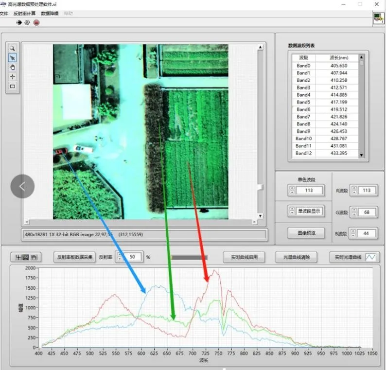
The Introduction of Hyperspectral Data Analysis Software
● The Function of The Software
1. Data Import: Raw data, spectral calibration files, relative calibration files.
2. Data Segmentation: Trajectory clipping, data clipping, data preview, spectral display, trajectory display.
3. Data Correction: Non-uniform correction, target extraction, reflectance calculation, geometric correction, image display.
4. Flightline Mosaic: Automatic mosaicking, mosaic line editing.
5. Data Export: Tile export, full-frame export.
6. Acquisition Functions: Spectral camera control, data acquisition, auto exposure, auto scan speed matching, auxiliary camera functionality, remote control support, cruise + inertial navigation acquisition mode, data support for third-party analysis software like ENVI.
7. Data Preprocessing Functions: Reflectance correction, region correction, radiance correction, spectral and image data preview, etc. (Free updates within one year).
● UAV Hyperspectral Multi-parameter Analysis Workflow for Water Bodies
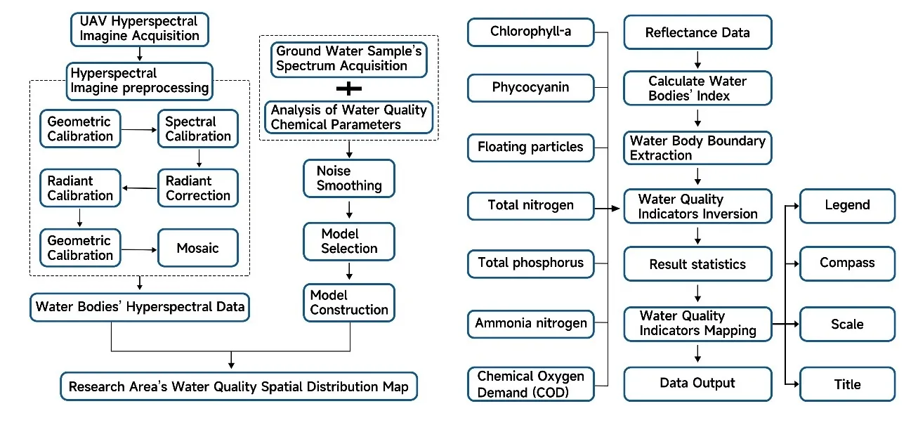
UAV Hyperspectral Water Sensing Roadmap
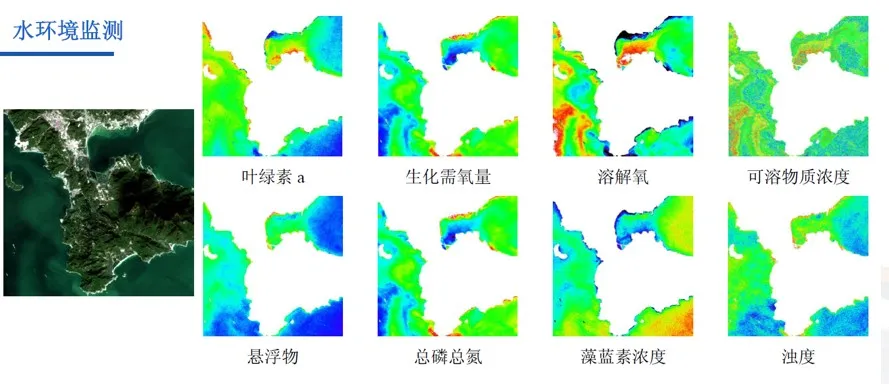
An integrated water quality monitoring solution based on hyperspectral technology, encompassing various products including unmanned aerial vehicles, ground-fixed points, and surface or underwater equipment. It provides real-time monitoring of river water bodies through quantitative inversion, measuring multiple parameters such as total nitrogen, total phosphorus, chlorophyll, ammonia nitrogen, turbidity, and the Chemical Oxygen Demand (COD) index.
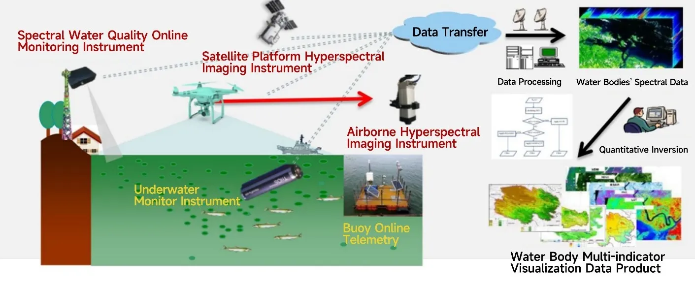
Multidimensional spatial water quality monitoring scheme
● Preprocessing of Unmanned Aerial Vehicle (UAV) Hyperspectral Data
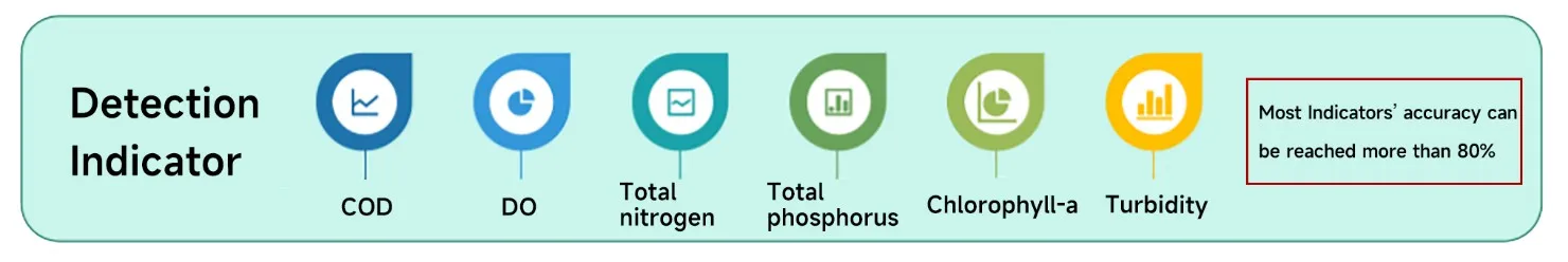
The rapid visualization function for water quality inversion includes analytical software, enabling image viewing, water body extraction, water quality parameter inversion, result statistics, and water quality parameter mapping, among other features. The image viewing function allows the importing and viewing of processed hyperspectral reflectance data, with point selection. The water body extraction function first calculates the water body index, followed by water body boundary extraction. Water quality parameter inversion can achieve the inversion of water body parameters such as chlorophyll-a, suspended matter, total nitrogen, total phosphorus, ammonia nitrogen, and chemical oxygen demand. The result statistics and water quality parameter mapping function allow for data output of the inverted parameters, displaying different concentration levels with various colour blocks, and achieving an accuracy of over 80% for most indicators.
|
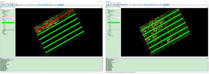
(Segmentation Based on Flight Tracks) |
Tape Splicing (Shown after Splicing) |
The Introduction of Hyperspectral Data Analysis Software
● The Function of The Software
1. Data Import: Raw data, spectral calibration files, relative calibration files.
2. Data Segmentation: Trajectory clipping, data clipping, data preview, spectral display, trajectory display.
3. Data Correction: Non-uniform correction, target extraction, reflectance calculation, geometric correction, image display.
4. Flightline Mosaic: Automatic mosaicking, mosaic line editing.
5. Data Export: Tile export, full-frame export.
6. Acquisition Functions: Spectral camera control, data acquisition, auto exposure, auto scan speed matching, auxiliary camera functionality, remote control support, cruise + inertial navigation acquisition mode, data support for third-party analysis software like ENVI.
7. Data Preprocessing Functions: Reflectance correction, region correction, radiance correction, spectral and image data preview, etc. (Free updates within one year).
● UAV Hyperspectral Multi-parameter Analysis Workflow for Water Bodies
UAV Hyperspectral Water Sensing Roadmap
An integrated water quality monitoring solution based on hyperspectral technology, encompassing various products including unmanned aerial vehicles, ground-fixed points, and surface or underwater equipment. It provides real-time monitoring of river water bodies through quantitative inversion, measuring multiple parameters such as total nitrogen, total phosphorus, chlorophyll, ammonia nitrogen, turbidity, and the Chemical Oxygen Demand (COD) index.
Multidimensional spatial water quality monitoring scheme
● Preprocessing of Unmanned Aerial Vehicle (UAV) Hyperspectral Data
The rapid visualization function for water quality inversion includes analytical software, enabling image viewing, water body extraction, water quality parameter inversion, result statistics, and water quality parameter mapping, among other features. The image viewing function allows the importing and viewing of processed hyperspectral reflectance data, with point selection. The water body extraction function first calculates the water body index, followed by water body boundary extraction. Water quality parameter inversion can achieve the inversion of water body parameters such as chlorophyll-a, suspended matter, total nitrogen, total phosphorus, ammonia nitrogen, and chemical oxygen demand. The result statistics and water quality parameter mapping function allow for data output of the inverted parameters, displaying different concentration levels with various colour blocks, and achieving an accuracy of over 80% for most indicators.
|
(Segmentation Based on Flight Tracks) |
Tape Splicing (Shown after Splicing) |
Application
Main Technical Indicators
liSpecHyper-VM200 Series
|
Model |
iSpecHyper-VM100-SCE |
iSpecHyper-VM100-Pro |
|
Spectral Range |
400-1000nm |
|
|
Spectral Resolution |
≤3.5nm(4x) |
≤2.5nm(4x) |
|
Spatial Resolution |
0.71mrad @F=35mm |
|
|
FOV |
15.6°@F=35mm |
|
|
Spatial Channels |
1920(1x),960(2x),480(4x) (Adjustable) |
|
|
Spectral Channels |
1200(1x),600(2x),300(4x) (Adjustable) |
|
|
Detector Type |
CMOS |
|
|
Detector Interface |
USB 3.0 |
|
|
Detector Target |
1/1.2” , 11.3mm x 7.1mm |
|
|
Detector’s Original Resolution |
1920 x 1200 |
|
|
Detectors’ Original Pixels Size |
5.86 µm x 5.86 µm |
|
|
Pixel Bit Depth |
12bits |
|
|
FPS |
Full-spectrum Data Acquisition with 41fps |
Full-spectrum Data Acquisition with 128fps max |
|
Lens Focal Length |
16mm/25mm/35mm Optional |
|
|
High-definition Camera Pixels |
500w |
1500w |
|
Self-Stabilizing System |
High-Stability Gimbal, Two-Axis with 2 Motors, Stabilizing Accuracy of 0.08° |
|
|
UAV Data Acquisition system |
CPU:I7,Memory:8GB, Hard Disk:128GB |
CPU:I7, Memory:16GB,Hard Disk:1TB |
|
Remote Intelligent Control System (Including Ground Station) |
Real-Time Spectrum Viewing, Remote Intelligent Control |
|
|
GNSS/INS |
GPS:RTK Supported, Positioning Accuracy :10CM |
GPS:RTK Supported, Positioning Accuracy :11CM |
|
Weight |
About 2.9kg |
About 3kg |
|
Power Consumption |
About 30w |
About 35w |
|
Onboard Data Acquisition and Control Software |
Acquisition Control、Real-Time Spectrum Picture & Diagram Preview, etc. |
Acquisition Control、Real-Time Spectrum Picture & Diagram Preview, Real-Time Parameter Inversion, etc. |
|
Ground-based Remote Intelligent Control Software |
Remote Intelligence Control |
|
|
Accessories |
High-Stability Tripod, Ground Station Power Module (12V, 19200mah), illuminance Meter, Wireless Keyboard and Mouse, Data USB Drive, Etc. |
|
liSpecHyper-VM200 Series
|
Model |
iSpecHyper-VM200-SCE |
iSpecHyper-VM200-Pro |
|
Spectral Range |
400-1000nm |
|
|
Spectral Resolution |
≤3.5nm(4x) |
≤2.5nm(4x) |
|
Spatial Resolution |
0.71mrad @F=35mm |
|
|
FOV |
15.6°@F=35mm |
|
|
Spatial Channels |
1920(1x),960(2x),480(4x), (Adjustable) |
|
|
Spectral Channels |
1200(1x),600(2x),300(4x), (Adjustable) |
|
|
Detector Type |
CMOS |
|
|
Detector Interface |
USB 3.0 |
|
|
Detector Target |
1/1.2”,11.3mm x 7.1mm |
|
|
Detector’s Original Resolution |
1920 x 1200 |
|
|
Detectors’ Original Pixels Size |
5.86 µm x 5.86 µm |
|
|
Pixel Bit Depth |
12bits |
|
|
FPS |
Full-spectrum Data Acquisition with 41fps |
Full-spectrum Data Acquisition with 128fps max |
|
Lens Focal Length |
12.5mm/16mm/25mm/35mm optional |
|
|
High-definition Camera Pixels |
1500w |
|
|
Self-Stabilizing System |
High-Stability Gimbal, Two-Axis with 2 Motors, Stabilizing Accuracy of 0.08° |
|
|
UAV Data Acquisition system |
CPU:I7, Memory:16GB, Hard Disk:1TB |
|
|
Remote Intelligent Control System (Including Ground Station) |
Real-Time Spectrum Diagram Preview,Remote Intelligence Control |
|
|
GNSS/INS |
GPS:RTK Supported, Positioning Accuracy :10CM |
GPS:RTK Supported, Positioning Accuracy :10CM IMU Attitude Angle Accuracy :0.01° |
|
Weight |
About 4.5kg |
About 5kg |
|
Power Consumption |
About 40w |
45w |
|
Onboard Data Acquisition and Control Software |
Acquisition Control、Real-Time Spectrum Picture & Diagram Preview, etc. |
Acquisition Control、Real-Time Spectrum Picture & Diagram Preview, Real-Time Parameter Inversion, etc. |
|
Ground-based Remote Intelligent Control Software |
Remote Intelligence Control |
|
|
Accessories |
High-Stability Tripod, Ground Station Power Module (12V, 19200mah), illuminance Meter, Wireless Keyboard and Mouse, Data USB Drive, Etc. |
|
liSpecHyper-VM400 Series
|
Model |
iSpecHyper-VM400-SCE |
iSpecHyper-VM400-Pro |
|
Spectral Range |
900-1700nm |
|
|
Spectral Resolution |
Better than 5nm |
|
|
Spatial Resolution |
0.85mrad@f=35mm |
|
|
FOV |
15.6°@F=35mm |
|
|
Spatial Channels |
320 |
640 |
|
Spectral Channels |
256 |
512 |
|
Detector Type |
InGaAs(TE Cooled) |
|
|
Detector Interface |
GigE |
Camera-Link |
|
Detector Target |
9.6mm x 7.68mm |
|
|
Detector’s Original Resolution |
320*256 |
640*512 |
|
Detectors’ Original Pixels Size |
30 µm x30 µm |
15 µm x15 µm |
|
Pixel Bit Depth |
14 bits |
|
|
FPS |
Full-spectrum Data Acquisition with 100fps max |
Full-spectrum Data Acquisition with 300fps max |
|
Lens Focal Length |
25mm/35mm optional |
|
|
High-definition Camera Pixels |
1500w |
|
|
Self-Stabilizing System |
High-Stability Gimbal, Two-Axis with 2 Motors, Stabilizing Accuracy of 0.08° |
|
|
UAV Data Acquisition system |
CPU:I7, Memory:16GB, Hard Disk:1TB |
|
|
Remote Intelligent Control System (Including Ground Station) |
Real-Time Spectrum Diagram Preview,Remote Intelligence Control |
|
|
GNSS/INS |
GPS:RTK Supported, Positioning Accuracy :10CM |
GPS:RTK Supported, Positioning Accuracy :10CM IMU Attitude Angle Accuracy :0.01° |
|
Weight |
About 6kg |
|
|
Power Consumption |
About 50w |
|
|
Onboard Data Acquisition and Control Software |
Acquisition Control、Real-Time Spectrum Picture & Diagram Preview, Real-Time Parameter Inversion, etc. |
|
|
Ground-based Remote Intelligent Control Software |
Remote Intelligence Control |
|
|
Accessories |
High-Stability Tripod, Ground Station Power Module (12V, 19200mah), illuminance Meter, Wireless Keyboard and Mouse, Data USB Drive, Etc. |
|
![]() Typical Application
Typical Application
● Applications in the Agricultural and Forestry
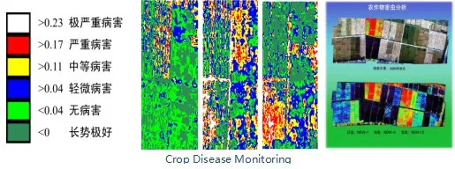
1. Agricultural and Forestry Disaster Monitoring
Using hyperspectral imaging to monitor the severity of crop pests and diseases and the growth status of crops. The degree of disease can be determined based on the colors in the images. For example, the following image:
Using forest vegetation coverage and soil-related indices to monitor the occurrence and severity of forest fires. This monitoring is crucial for evaluating large-scale forest fire occurrences and their economic impacts.
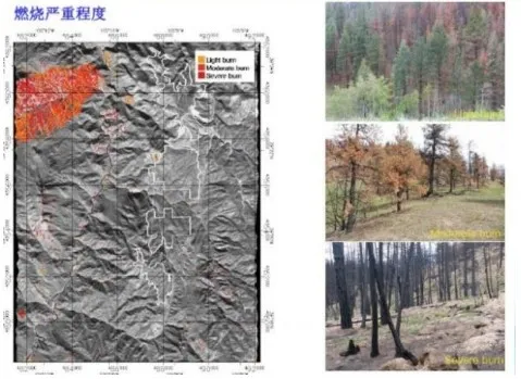
Forest Fire Monitoring
2. Precision Agriculture and Forestry Data Monitoring
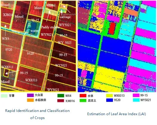
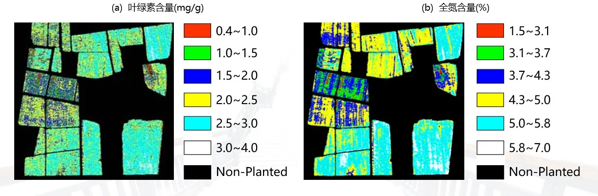
Hyperspectral remote sensing is applied in agriculture to monitor the nutrient supply status of crops, enabling timely assessment of crop growth and implementation of effective measures to enhance yields. It focuses on identifying and analyzing nutrient imbalances in crops and soil within specific areas. Additionally, when dealing with multiple crops, quick and accurate classification is crucial as different crops may require varying types and amounts of fertilizers. By utilizing UAV hyperspectral systems, which offer a greater number of spectral bands and higher resolution compared to multispectral systems, it becomes possible to capture different responses from various crops across different wavelengths. This facilitates rapid and efficient crop identification, with recognition rates reaching up to 95%.
3. Vegetation/Agroforestry Ecological Survey
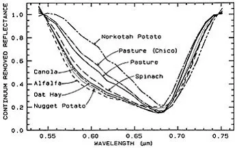
Non-photosynthetic components in vegetation cannot be measured with traditional broadband spectrometry, but they can be easily measured and separated using hyperspectral imaging. Therefore, quantitative analysis of the chemical composition of canopies can be achieved through hyperspectral remote sensing to monitor changes in plant functions caused by atmospheric and environmental variations.
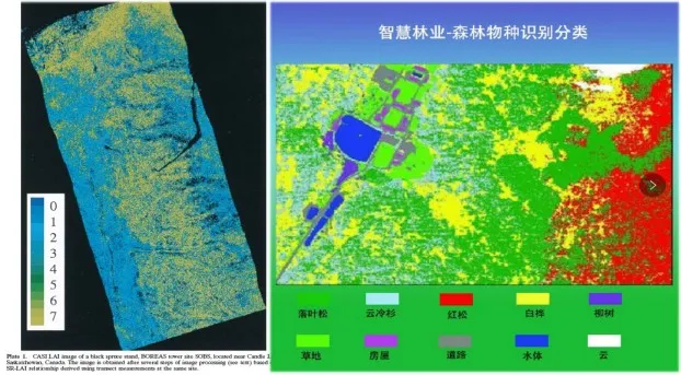
● Classification and identification of vegetation communities and species;
● Evaluation of canopy structure, status, or vitality, estimation of canopy hydrological status and biochemical properties;
● Study of the basic biophysical and biochemical composition of leaves.
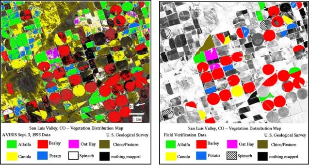
AVIRIS Vegetation Classification Mapping with a Validation Accuracy of up to 90%
Crop Biochemical Component Mapping
Applications in Water Quality, Geology, and Environmental Monitoring
1. Water Quality Monitoring
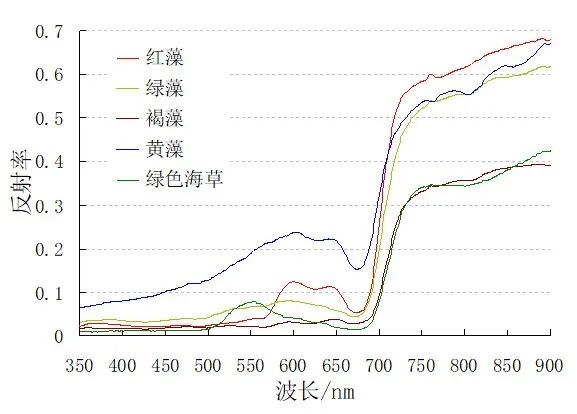
The fine spectral resolution of hyperspectral remote sensing data can be used to identify and estimate the content of chlorophyll, tannic acid, and sediments in water bodies. This helps in monitoring algal growth and inferring the distribution of plankton and fish populations in aquatic research.
● Estimating and analyzing the absorption and scattering components in water bodies, such as chlorophyll, phytoplankton, non-soluble organic matter, suspended sediments, and semi-submerged aquatic plants.
● Identifying and estimating the content of chlorophyll, yellow substances, and suspended matter in water bodies for water quality monitoring.
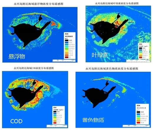
● Monitoring algal growth, plankton distribution, and fish population locations by estimating chlorophyll content, as well as estimating the biomass of plankton and primary productivity.
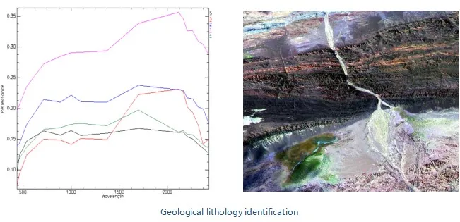
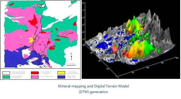
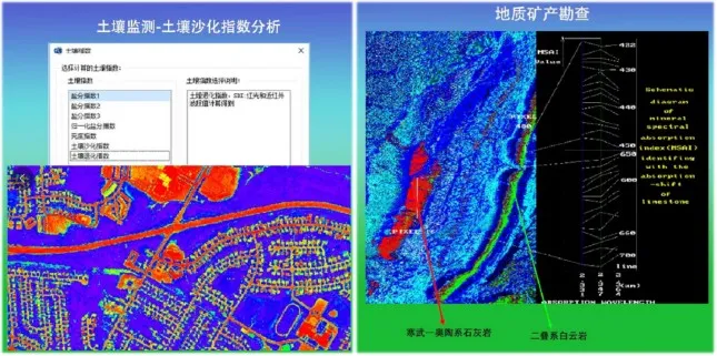
2. Geological Exploration/Soil Monitoring
Hyperspectral remote sensing technology is used for mineral identification on the Earth's surface, particularly effective in locating hydrothermal alteration deposits. It is also utilized for geochemical mapping and geological mapping. In the geological field, hyperspectral remote sensing plays a crucial role in directly identifying different rock types based on their measured spectral features, allowing for the direct extraction of lithology.
Different elements in the earth's materials correspond to distinct response bands in the spectral response. Different minerals exhibit varying responses within the mid to far-infrared range. As a result, detailed information about minerals can be extracted based on their chemical composition.
3. Environmental Monitoring
The red edge position is the point in the spectral curve of green plants where the reflectance increases most rapidly within the wavelength range of 680nm to 760nm. It corresponds to the inflection point of the curve in this range. The red edge position can indirectly reflect the growth and health status of vegetation. When vegetation is in good condition and thriving, the red edge position shifts to the right. Conversely, when the vegetation is stressed or not healthy, the red edge position shifts to the left, which is commonly referred to as "blue shift." Monitoring changes in the red edge position can provide valuable information about the physiological condition of vegetation and its response to environmental factors.
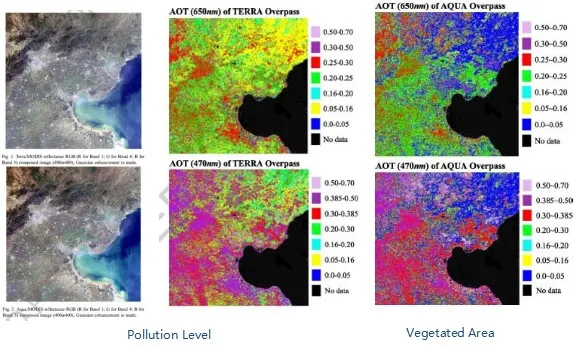
4. Atmospheric Environmental Assessment
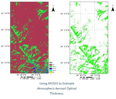
The molecular and particle components of the atmosphere have a strong response in the solar reflectance spectrum, and conventional broad-band remote sensing methods are unable to recognize spectral differences due to changes in atmospheric composition; hyperspectral is able to recognize subtle differences in the spectral curves because of its narrow band.
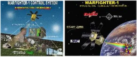
● Military Applications
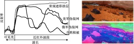
According to the difference between the target spectrum and the spectral properties of camouflage materials, the use of hyperspectral technology can automatically discover the target from the camouflage objects, in the investigation of weapons production, hyper-spectral imaging spectrometer not only detects the spectral properties of the target, the existence of the situation, and even analyze its material composition, according to the spectral properties of the factory-generated smoke, and the direct identification of its material composition, so that it can be determined the type of factory-produced weapons, in particular, attacking weapons using short-wave infrared hyper-spectral imaging to identify camouflage nets in the battlefield environment, the above figure is the original image of the true color, and the next figure is the image of the camouflage nets identified by the processed.
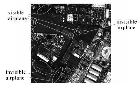
Detection of small aircraft targets in airports by airborne hyperspectral, extracting the mean spectra of aircraft targets as the target spectra for detection in the original image, and adopting target detection algorithms to extract non-visible small targets in airports.
Application
Main Technical Indicators
liSpecHyper-VM200 Series
|
Model |
iSpecHyper-VM100-SCE |
iSpecHyper-VM100-Pro |
|
Spectral Range |
400-1000nm |
|
|
Spectral Resolution |
≤3.5nm(4x) |
≤2.5nm(4x) |
|
Spatial Resolution |
0.71mrad @F=35mm |
|
|
FOV |
15.6°@F=35mm |
|
|
Spatial Channels |
1920(1x),960(2x),480(4x) (Adjustable) |
|
|
Spectral Channels |
1200(1x),600(2x),300(4x) (Adjustable) |
|
|
Detector Type |
CMOS |
|
|
Detector Interface |
USB 3.0 |
|
|
Detector Target |
1/1.2” , 11.3mm x 7.1mm |
|
|
Detector’s Original Resolution |
1920 x 1200 |
|
|
Detectors’ Original Pixels Size |
5.86 µm x 5.86 µm |
|
|
Pixel Bit Depth |
12bits |
|
|
FPS |
Full-spectrum Data Acquisition with 41fps |
Full-spectrum Data Acquisition with 128fps max |
|
Lens Focal Length |
16mm/25mm/35mm Optional |
|
|
High-definition Camera Pixels |
500w |
1500w |
|
Self-Stabilizing System |
High-Stability Gimbal, Two-Axis with 2 Motors, Stabilizing Accuracy of 0.08° |
|
|
UAV Data Acquisition system |
CPU:I7,Memory:8GB, Hard Disk:128GB |
CPU:I7, Memory:16GB,Hard Disk:1TB |
|
Remote Intelligent Control System (Including Ground Station) |
Real-Time Spectrum Viewing, Remote Intelligent Control |
|
|
GNSS/INS |
GPS:RTK Supported, Positioning Accuracy :10CM |
GPS:RTK Supported, Positioning Accuracy :11CM |
|
Weight |
About 2.9kg |
About 3kg |
|
Power Consumption |
About 30w |
About 35w |
|
Onboard Data Acquisition and Control Software |
Acquisition Control、Real-Time Spectrum Picture & Diagram Preview, etc. |
Acquisition Control、Real-Time Spectrum Picture & Diagram Preview, Real-Time Parameter Inversion, etc. |
|
Ground-based Remote Intelligent Control Software |
Remote Intelligence Control |
|
|
Accessories |
High-Stability Tripod, Ground Station Power Module (12V, 19200mah), illuminance Meter, Wireless Keyboard and Mouse, Data USB Drive, Etc. |
|
liSpecHyper-VM200 Series
|
Model |
iSpecHyper-VM200-SCE |
iSpecHyper-VM200-Pro |
|
Spectral Range |
400-1000nm |
|
|
Spectral Resolution |
≤3.5nm(4x) |
≤2.5nm(4x) |
|
Spatial Resolution |
0.71mrad @F=35mm |
|
|
FOV |
15.6°@F=35mm |
|
|
Spatial Channels |
1920(1x),960(2x),480(4x), (Adjustable) |
|
|
Spectral Channels |
1200(1x),600(2x),300(4x), (Adjustable) |
|
|
Detector Type |
CMOS |
|
|
Detector Interface |
USB 3.0 |
|
|
Detector Target |
1/1.2”,11.3mm x 7.1mm |
|
|
Detector’s Original Resolution |
1920 x 1200 |
|
|
Detectors’ Original Pixels Size |
5.86 µm x 5.86 µm |
|
|
Pixel Bit Depth |
12bits |
|
|
FPS |
Full-spectrum Data Acquisition with 41fps |
Full-spectrum Data Acquisition with 128fps max |
|
Lens Focal Length |
12.5mm/16mm/25mm/35mm optional |
|
|
High-definition Camera Pixels |
1500w |
|
|
Self-Stabilizing System |
High-Stability Gimbal, Two-Axis with 2 Motors, Stabilizing Accuracy of 0.08° |
|
|
UAV Data Acquisition system |
CPU:I7, Memory:16GB, Hard Disk:1TB |
|
|
Remote Intelligent Control System (Including Ground Station) |
Real-Time Spectrum Diagram Preview,Remote Intelligence Control |
|
|
GNSS/INS |
GPS:RTK Supported, Positioning Accuracy :10CM |
GPS:RTK Supported, Positioning Accuracy :10CM IMU Attitude Angle Accuracy :0.01° |
|
Weight |
About 4.5kg |
About 5kg |
|
Power Consumption |
About 40w |
45w |
|
Onboard Data Acquisition and Control Software |
Acquisition Control、Real-Time Spectrum Picture & Diagram Preview, etc. |
Acquisition Control、Real-Time Spectrum Picture & Diagram Preview, Real-Time Parameter Inversion, etc. |
|
Ground-based Remote Intelligent Control Software |
Remote Intelligence Control |
|
|
Accessories |
High-Stability Tripod, Ground Station Power Module (12V, 19200mah), illuminance Meter, Wireless Keyboard and Mouse, Data USB Drive, Etc. |
|
liSpecHyper-VM400 Series
|
Model |
iSpecHyper-VM400-SCE |
iSpecHyper-VM400-Pro |
|
Spectral Range |
900-1700nm |
|
|
Spectral Resolution |
Better than 5nm |
|
|
Spatial Resolution |
0.85mrad@f=35mm |
|
|
FOV |
15.6°@F=35mm |
|
|
Spatial Channels |
320 |
640 |
|
Spectral Channels |
256 |
512 |
|
Detector Type |
InGaAs(TE Cooled) |
|
|
Detector Interface |
GigE |
Camera-Link |
|
Detector Target |
9.6mm x 7.68mm |
|
|
Detector’s Original Resolution |
320*256 |
640*512 |
|
Detectors’ Original Pixels Size |
30 µm x30 µm |
15 µm x15 µm |
|
Pixel Bit Depth |
14 bits |
|
|
FPS |
Full-spectrum Data Acquisition with 100fps max |
Full-spectrum Data Acquisition with 300fps max |
|
Lens Focal Length |
25mm/35mm optional |
|
|
High-definition Camera Pixels |
1500w |
|
|
Self-Stabilizing System |
High-Stability Gimbal, Two-Axis with 2 Motors, Stabilizing Accuracy of 0.08° |
|
|
UAV Data Acquisition system |
CPU:I7, Memory:16GB, Hard Disk:1TB |
|
|
Remote Intelligent Control System (Including Ground Station) |
Real-Time Spectrum Diagram Preview,Remote Intelligence Control |
|
|
GNSS/INS |
GPS:RTK Supported, Positioning Accuracy :10CM |
GPS:RTK Supported, Positioning Accuracy :10CM IMU Attitude Angle Accuracy :0.01° |
|
Weight |
About 6kg |
|
|
Power Consumption |
About 50w |
|
|
Onboard Data Acquisition and Control Software |
Acquisition Control、Real-Time Spectrum Picture & Diagram Preview, Real-Time Parameter Inversion, etc. |
|
|
Ground-based Remote Intelligent Control Software |
Remote Intelligence Control |
|
|
Accessories |
High-Stability Tripod, Ground Station Power Module (12V, 19200mah), illuminance Meter, Wireless Keyboard and Mouse, Data USB Drive, Etc. |
|
![]() Typical Application
Typical Application
● Applications in the Agricultural and Forestry
1. Agricultural and Forestry Disaster Monitoring
Using hyperspectral imaging to monitor the severity of crop pests and diseases and the growth status of crops. The degree of disease can be determined based on the colors in the images. For example, the following image:
Using forest vegetation coverage and soil-related indices to monitor the occurrence and severity of forest fires. This monitoring is crucial for evaluating large-scale forest fire occurrences and their economic impacts.
Forest Fire Monitoring
2. Precision Agriculture and Forestry Data Monitoring
Hyperspectral remote sensing is applied in agriculture to monitor the nutrient supply status of crops, enabling timely assessment of crop growth and implementation of effective measures to enhance yields. It focuses on identifying and analyzing nutrient imbalances in crops and soil within specific areas. Additionally, when dealing with multiple crops, quick and accurate classification is crucial as different crops may require varying types and amounts of fertilizers. By utilizing UAV hyperspectral systems, which offer a greater number of spectral bands and higher resolution compared to multispectral systems, it becomes possible to capture different responses from various crops across different wavelengths. This facilitates rapid and efficient crop identification, with recognition rates reaching up to 95%.
3. Vegetation/Agroforestry Ecological Survey
Non-photosynthetic components in vegetation cannot be measured with traditional broadband spectrometry, but they can be easily measured and separated using hyperspectral imaging. Therefore, quantitative analysis of the chemical composition of canopies can be achieved through hyperspectral remote sensing to monitor changes in plant functions caused by atmospheric and environmental variations.
● Classification and identification of vegetation communities and species;
● Evaluation of canopy structure, status, or vitality, estimation of canopy hydrological status and biochemical properties;
● Study of the basic biophysical and biochemical composition of leaves.
AVIRIS Vegetation Classification Mapping with a Validation Accuracy of up to 90%
Crop Biochemical Component Mapping
Applications in Water Quality, Geology, and Environmental Monitoring
1. Water Quality Monitoring
The fine spectral resolution of hyperspectral remote sensing data can be used to identify and estimate the content of chlorophyll, tannic acid, and sediments in water bodies. This helps in monitoring algal growth and inferring the distribution of plankton and fish populations in aquatic research.
● Estimating and analyzing the absorption and scattering components in water bodies, such as chlorophyll, phytoplankton, non-soluble organic matter, suspended sediments, and semi-submerged aquatic plants.
● Identifying and estimating the content of chlorophyll, yellow substances, and suspended matter in water bodies for water quality monitoring.
● Monitoring algal growth, plankton distribution, and fish population locations by estimating chlorophyll content, as well as estimating the biomass of plankton and primary productivity.
2. Geological Exploration/Soil Monitoring
Hyperspectral remote sensing technology is used for mineral identification on the Earth's surface, particularly effective in locating hydrothermal alteration deposits. It is also utilized for geochemical mapping and geological mapping. In the geological field, hyperspectral remote sensing plays a crucial role in directly identifying different rock types based on their measured spectral features, allowing for the direct extraction of lithology.
Different elements in the earth's materials correspond to distinct response bands in the spectral response. Different minerals exhibit varying responses within the mid to far-infrared range. As a result, detailed information about minerals can be extracted based on their chemical composition.
3. Environmental Monitoring
The red edge position is the point in the spectral curve of green plants where the reflectance increases most rapidly within the wavelength range of 680nm to 760nm. It corresponds to the inflection point of the curve in this range. The red edge position can indirectly reflect the growth and health status of vegetation. When vegetation is in good condition and thriving, the red edge position shifts to the right. Conversely, when the vegetation is stressed or not healthy, the red edge position shifts to the left, which is commonly referred to as "blue shift." Monitoring changes in the red edge position can provide valuable information about the physiological condition of vegetation and its response to environmental factors.
4. Atmospheric Environmental Assessment
The molecular and particle components of the atmosphere have a strong response in the solar reflectance spectrum, and conventional broad-band remote sensing methods are unable to recognize spectral differences due to changes in atmospheric composition; hyperspectral is able to recognize subtle differences in the spectral curves because of its narrow band.
● Military Applications
According to the difference between the target spectrum and the spectral properties of camouflage materials, the use of hyperspectral technology can automatically discover the target from the camouflage objects, in the investigation of weapons production, hyper-spectral imaging spectrometer not only detects the spectral properties of the target, the existence of the situation, and even analyze its material composition, according to the spectral properties of the factory-generated smoke, and the direct identification of its material composition, so that it can be determined the type of factory-produced weapons, in particular, attacking weapons using short-wave infrared hyper-spectral imaging to identify camouflage nets in the battlefield environment, the above figure is the original image of the true color, and the next figure is the image of the camouflage nets identified by the processed.
Detection of small aircraft targets in airports by airborne hyperspectral, extracting the mean spectra of aircraft targets as the target spectra for detection in the original image, and adopting target detection algorithms to extract non-visible small targets in airports.
Get Your Free Spectral Analysis Solution.
Tell us about your requirements. Our experts will contact you within 24 hours.
Focus on spectral sensing and optoelectronic application systems